The NRMA (National Roads and Motorways Authority) is the government agency in charge building and maintaining all motorways and major highways in Craftia. Its headquaters is in Bankera , BCT. The agency was formed in 2020 when it was decided that a reform of the nation's major roads was needed. Highways were reformed in 2021 and motorways followed in 2024.
History[]
Leading up to the creation of the NRMA in 2020, Craftia's interstate road network was inconststent, often poorly maintained and did not link up very well. The government created the National Roads and Motorways Authority to reform and then run the county's road network. All major highways (national highways) and motorways were handed over to the NRMA and within a year all national highways had begun to be reformed. This included upgrading roads to an acceptable standard, placing new signage and numbering the roads under the new alpha-numeric system. In 2024 all the motorways had the same things done to them. Since then the number of national highways has grown from 7 to 12 and the motorways have grown from 4 to 10, with the M11 under construction and nearing completion.
List of Roads[]
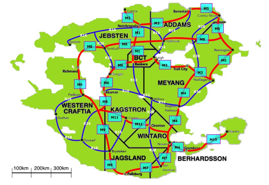
The alpha-numeric code given to each road indicates what order they were built in. All motorways begin with an M and all national highways begin with an R.
| Code | Start | Finish | States | Length (km) | Opened |
|---|---|---|---|---|---|
| M1 | Notchropolis | Bankera | 2 | 212 | 2001 |
| M2 | Calmia | Bonestan | 2 | 384 | 2009 |
| M3 | Bankera | Yoollagarra | 2 | 420 | 2016 |
| M4 | M3/M4 intersection | Grumbroe | 3 | 521 | 2017 |
| M5 | Bonestan | Yoollagarra | 2 | 369 | 2025 |
| M6 | Bankera | M6/M9/M11 intersection | 4 | 327 | 2028 |
| Clontarf | Extension to open in 2076 | ||||
| M7 | Novena | Pallsburg | 3 | 234 | 2038 |
| M8 | Richmond | M5/M8 intersection | 4 | 691 | 2045 |
| M9 | Richmond | Pallsburg | 2 | 730 | 2048 |
| M10 | Grumbroe | Hijanke | 1 | 255 | 2059 |
| M11 | M6/M9/M11 intersection | M4/M9 intersection | 3 | 307 | 2067 |
| M25 | Notchropolis Orbital Motorway | 1 | 64 | 2052 | |
- R10- Twixton to Holbrook
- R12- Bankera to Stigston Harbour
- R14- Bonestan to Leigh
- R16- Akarran to R12/R16 int.
- R18- Padbury to Centro
- R20- Canley Shore to M3/M4/R20 int.
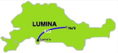
- R22- Ha'ii to Luma'a
- R24- M6/M9/M11/R24 int. to Clontarf (To be replaced by M6 extension in 2076)
- R26- R10/R26 int. to Dongjin
- R28- Wilkins to San Andreas
- R30- Yoollagarra to Stigston Harbour
Network Map[]
Lumina NRMA roadmap
Other Roads[]
All other roads in Craftia are built and maintained by state governments and local councils. There is little continuity of roads throughout the country not under the NRMA's authority, even to the point where one road may have multiple alphanumeric codes depending on its state/territory. There have been suggestions since the 2020's that all class 1 roads nationwide are transferred to the NRMA but this has never happened.
Coding system for other roads[]
Other than roads under the authority of the NRMA, each state and territory chooses its own coding system. Addams, BCT and Jesbten use the same system. Jagsland and Wintaro use the same system with the exception of Tollways. Lumina is the only state without its own class 1 type of road.
| System | Class 1 (A) | Class 2 (B) | Class 3 (C) | ||
|---|---|---|---|---|---|
| Addams | 1 | Highway | Main Road | ||
| BCT | 1 | Highway | Main Road | ||
| Berhardsson | 2 | Primary Road | Secondary Road | Tertiary Road (T) | |
| Jagsland | 2 | Primary Road | Secondary Road | Tertiary Road (T) | |
| Jebsten | 1 | Highway | Main Road | ||
| Kagstron | 1 | Highway | Main Road | ||
| Lumina | 3 | Expressway | Arterial Road | Major Road (C) | |
| Meyang | 1 | Highway | Main Road | ||
| Western Craftia | 3 | Expressway | Arterial Road | Major Road (C) | |
| Wintaro | 2 | Primary Road | Secondary Road | Tertiary Road (T) | |