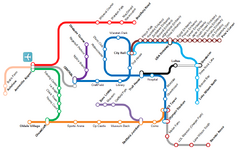
The NotchRail Network Map is an important part of the NotchRail system's identity. The map is a schematic diagram of the network which is based on the former CityRail map in Sydney, Australia.
Network Map[]
There are currently five main versions of the map. The first one was made using eDraw software and was updated from the early 2030's until 2040. The second one was made using GIMP and Paint.net and was first released in 2040. It was phased out in favour of a new one in 2057, which is based on the second map but with smoother curves, thinner lines and a less cramped design. In 2071, as part of Project Revolution, a fourth map was created, in a completely revamped style. This change did not last long, however, and in 2072, a revamped third map replaced the fourth map. In 2073, a remade version of the fourth map replaced the third map as the current network map of NotchRail today.
- Map 1: eDraw style
- Map 2: Early 1990s CityRail network map style
- Map 3: 2000s CityRail network map style
- Map 4: 2010s Sydney Trains network map style
- Map 5: 2010s Sydney Trains network map style
- Map 6: 2010s Sydney Trains network map style
- Map 7: 2010s Sydney Trains network map style
- Metro Rail Map: 2010s Sydney Trains network map style
Server: NotchRail Network[]
The first NotchRail line built on the server was the City Line from Central to The Farm via Cemetery, Town Hall and Rollercoaster. It was built somewhere between May and September 2012. Unfortunately there are very few records of NotchRail's progress prior to September 2012.
NotchRail Network Server Timeline[]
| Line | Project Type | Stations | Opening | |||
|---|---|---|---|---|---|---|
| No. | List | Server (approx) | MY | |||
| City | New Line | 6 | Central, Cemetery, Town Hall, Rollercoaster, Hospital, The Farm | May 2012 | Aug 2012 | 1992 |
| City | Ext. and
new stations |
7 | Craftfield, Troll House, Waratah Park, Obstacle Course,
Bomberman Arena, CS Tower, Olympic Stadium |
May 2012 | Aug 2012 | 2013 |
| Downtown | New Line | 4 | CS Tower, Tower Defence Back, Museum Junction, Op Castle/ Safari Zone | May 2012 | Sep 2012 | 2024 |
| Tunnel | New Line | 4 | Central, Notice Board, Ragequit Parkour, Obstacle Course | May 2012 | Sep 2012 | 2008 |
| Downtown | Ext. and
new stations |
3 | Museum Back, Sports Arena, Chesscraft | Jun 2012 | Sep 2012 | 2035 |
| Museum | New Line | 3 | Museum Junction, Suicide Booth, Museum | Jun 2012 | Sep 2012 | 2058 |
| Embassy | New Line | 6 | Town Hall, Piston Park, Australia Embassy, Zimbabwe Embassy, Burundi Embassy,
Afghanistan Embassy |
Jul
2012 |
Sept 2012 | 2014 |
| Embassy | Extension | 10 | China Embassy, USA Embassy, Egypt Embassy, France Embassy, Taiwan Embassy, South Korea Embassy, North Korea Embassy, Jamaica Embassy, UK Embassy | Sep 2012 | 2016 | |
| Downtown | Extention | 1 | Oldale Village | Sep 2012 | 2035 | |
| Le Angel | New Line | 4 | Chesscraft, Tennis Court, Clock Tower, Le Angel | Sep 2012 | 2029 | |
| Le Angel | Extention | 2 | Training Centre, Airport | Oct 2012 | Nov 2012 | 2032 |
| Questacon | New Line | 2 | USA Embassy, Questacon | Nov 2012 | 2025 | |
| Industrial South | New Line | 5 | CS Tower, Olympic Stadium, Melon Farm, LOL64o's Mansion, Lake Wilson | Nov 2012 | 2017 | |
| Industrial South | Extention | 1 | Slender Arena | Dec 2012 | 2027 | |
| Airport Express | New Line | 3 | Central, Police Station, Airport | Dec 2012 | Jan 2013 | 2040 |
| Achelous | New Line | 5 | Airport, Twinleaf Town, Littleroot Town, Bob's Farm, Achelous | Dec 2012 | Jan 2013 | 2032 |
| Embassy | Extension | 2 | Apperture Dam, Pete's Corner | Jan 2013 | Feb 2013 | 2025 |
| Lake(Questacon) | Extension | 4 | Town Hall, Three Rock Lake, Bonnet Bay, Lake Wilson North | Jan 2013 | Feb 2013 | 2048 |
| Allandale | New Line | 5 | Airport,Wipeout Course, Waratah Park, Macdonald Racecourse, Bradfield Road | Feb 2013 | 2031 | |
| Eastplains | New Line | 2 | Troll House, Loftus | Mar 2013 | 2037 | |
| NotchRail map V.1 published | Mar 2013 | 2033 | ||||
| Eastplains | Extension | 3 | Hespefield, Wharton Reserve, Questacon | Apr 2013 | 2037 | |
| Lake | New stations | 2 | Hespefield, Wharton Reserve | Apr 2013 | 2048 | |
| to be continued | ||||||


